

Tracks & Trails
Explore our bushland tracks, hilltop trails, and lakeside rambles - do you want a short hike to a waterfall, a steeper challenge, or a riverbank stroll with the kids? Waimate District's walking tracks and trails have something for everyone. To view the tracks on our interactive map click here.
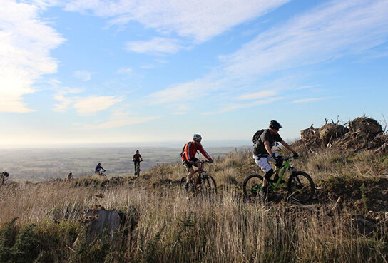
Whitehorse Big Easy
A shared mountain bike and walking track heads off to the right of the White Horse walkway through a mixture of bush and trees. This longer route to the White Horse monument has many deviations for mountain bike enthusiasts so always take care to look out for bikers coming both ways. There is an abundant number of tui, bellbird, and kereru and the occasional New Zealand native falcon mostly in the wooded area of this track.
Location: 228 Point Bush Road. Signage on the corner of Mill Road and Point Bush Road
Usage: Walking/biking
Time/distance: 2 hours return, 6.7km one way
Level of Fitness: Moderate - high
Dogs: No
Studholme Bush Tracks
A range of tracks in the hills overlooking Waimate, and along the old railway line through the Waimate Gorge. Something for every age and fitness level, from steep uphills to long, winding flats, and a waterfall. Hilltop views to the Pacific Ocean, and inland to the Southern Alps.
Location: 203 State Highway 82. Parking and signage on the Waimate side of the gorge
Usage: Walking
Time/distance: From 20 minutes
Level of Fitness: Low - high
Dogs: No
For more information on each track click here.
Download printable map of the walking and MTB tracks
Ngaio Track
If you really want to test your fitness, try getting to the top of the Ngaio track without stopping! You may see wallabies on the track, or hear them thumping through the bush. Start at the Studholme Bush carpark, the hill walk starts off gently enough, but you'll soon be winding straight up to the top of the hill. Just when you think you've reached the top, you'll turn a corner and see another stretch to go...
You'll feel great at the end and be rewarded with amazing views out to sea, and inland to Waihao Downs and Waihaorunga.
Location: 203 State Highway 82. Parking and signage on the Waimate side of the gorge
Usage: Walking
Time/Distance: 35 minutes one way
Level of Fitness: High
Dogs: No
Whitehorse Walkway
You can walk up to the Whitehorse monument, starting at the carpark at the top of Point Bush Road. The track is steep in parts, rising from 145 to 400m.
Follow the signs indicating walkway track. The track climbs grassy slopes and then left over a style before joining an old logging track, through remnants of Totara forest and emerging into modern day pine plantations. These are shared use tracks so keep an eye out for bikes, and other walkers and runners. Your steep walk will be rewarded with some magnificent views of the Pacific Ocean overlooking Waimate township and district farmlands.
Location: 228 Point Bush Road. Signage on the corner of Mill Road and Point Bush Road
Usage: Walking
Time/Distance: 2 hours return
Level of Fitness: High
Dogs: No
Naylors Track
This flat track starts on Queen Street and goes through to Point Bush Rd. You can cross the road there and join on to Garlands Track.
Location: Two minutes from the centre of town at the end of Queen Street
Usage: Walking/biking
Time/distance: 40 minutes return, 0.75 km
Level of Fitness: Low - moderate
Dogs: On a lead
Garlands Track
A tree-lined walkway alongside the Waimate Creek between Point Bush Road bridge and Garlands Road bridge. Also a great track for kids to learn mountain biking. Garlands Track is relatively flat; the Garlands Road loop is a gradual uphill.
Location: Two minutes from the centre of town on Point Bush Road
Usage: Walking/biking
Time: 1 hour return, 0.95 km
Level of Fitness: Low - moderate
Dogs: On a lead
Knottingley Park
A flat loop track around the park and arboretum, underplanted with masses of bulbs. Sheep and horses sometimes graze here, and please respect the animals and don't disturb them. Easy walk in parkland area with beautiful established trees. Suitable for walking and biking.
Location: Two minutes from the centre of Waimate, on Waihao Back Road
Usage: Walking/biking
Time: 30 minute circuit, 2.5 km
Level of Fitness: Low
Dogs: On a lead
Kelceys Bush Tracks
Beautiful bush at the base of the hills; two tracks, alongside and through a stream. If you're feeling adventurous you can make stepping stones with rocks and cross the streams and reach the first water supply station for the town of Waimate. Be prepared to get wet feet! A lovely place to picnic.
Location: Ten minutes from Waimate. Drive to the end of Mill Rd, the car park is at the very end of the road
Usage: Walking
Time: 20 mins (Sanders Falls) or 40 mins (Intake Track)
Level of Fitness: Low - medium
Dogs: On a lead
Gunns Bush Track
This track has moss hanging from the trees and an abundance of bird life. It's a great family track - kids love exploring the bush, crossing streams, and listening to the bird song. The track follows a river valley in amongst bush. At times it meanders beside the creek.
Location: Hunters Hills. Entrance is off Lower Hook Road, at Gunn’s Bush Camp, 13 km northwest of Waimate
Usage: Walking
Time/distance: 1.5 hours loop track, 3.5 km
Level of Fitness: Medium
Dogs: On a lead
Waihao River Walkway
This walkway runs alongside the south bank of the Waihao River between McCulloch’s Bridge and the Black Hole. The track offers views of nearby limestone cliffs and unique limestone outcrops. Brown trout and eels can be found in the river and there is abundant bird life along the track. Part of the track goes through a working farm. Close gates behind you, and don’t disturb stock.
Location: Fifteen minutes southwest of Waimate via SH82 and Kapua Road to McCullochs Bridge
Usage: Walking/biking
Time/distance: 45 minutes one way, 1.9 km
Level of Fitness: Low - moderate
Dogs: On a lead
Lake Wainono Wetland
Lake Wainono is considered a wetland of national importance, and a paradise for bird watchers.
Location: Start at either end of the track: Hook Beach Road or Poingdestres Road. The track can also be accessed from Wainono Lake Road, on SH1 opposite Nosh Cafe
Usage: Walking
Time/distance: 5 hours return, 7.7 km
Level of Fitness: Low - moderate
Dogs: No
Glenavy Track
This flat, approximately 1.2km, track wanders beside a stream under a small pine plantation just off State Highway One. The track is lined by large quantities of blackberry, which in late summer transform into a potential harvest field for walkers.
There are ample picnic places both half-way along the track beside the clear running stream, and at the bridge-end car park. Toilets and several picnic seats make this a very popular stopping point for travellers.
Location: Start at either end of the track: Park on Ruane Street, Glenavy and walk to the track across a paddock on a paper road, or park in the carpark on the north side of the Waitaki bridge
Usage: Walking/biking
Time: 45 minutes return, 0.94 km
Level of Fitness: Low
Dogs: Yes
Mt Nimrod Reserve
Beautiful walk through native broadleaf forest, with views to the coast as you climb. Native birds and (possibly) wallabies on the track as well.
The camping ground is one of the nicest in the district, and is a wonderful place to hear the dawn chorus.
Location: Hunters Hills. Off Back Line Road, 43 km northwest of Waimate
Usage: Walking
Time: 2-3 hours loop track, 2.9 km
Level of Fitness: High.
Dogs: No
Deep Stream Track
This track sidles steep faces within a flooded canyon. There are native plants along the track, including two rare native brooms - Carmichaelia curta and Carmichaelia kirkii. The walk finishes at the river delta where a shady picnic or fishing spot can be found.
Location: Turn off SH83 at Aviemore Dam onto Te Akatarawa Road
Usage: Walking
Time: 1 hour one way, 1.2 km
Level of Fitness: Medium
Dogs: No